Antarctica and Southern Ocean Hillshade and Bathymetry
- Collections
- Edition
- 1
- Published
Produced by the Mapping and Geographic Information Centre, British Antarctic Survey, 2026, version 1, https://data.bas.ac.uk/items/b40090f3-a13d-4918-ab05-7625a0b839d8.
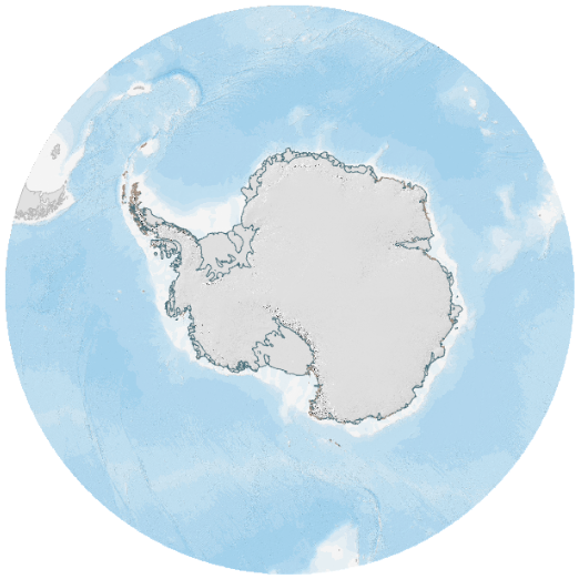
Hillshade and bathymetry compilation of Antarctica and the Southern Ocean, south of 50°S. Created by the Mapping and Geographic Information Centre, British Antarctic Survey.
Source data is reviewed and updated every 6-12 months to ensure coastline is up to date, and data sources are appropriate. Available as an Esri Tile Service. The tile layer can be used up to 1:110,000 scale.
Projection: WGS84 Antarctic Polar Stereographic, EPSG 3031
Data sources and references can be found in the lineage.
Add this item to a desktop or online GIS that supports ArcGIS Raster (Map) Tiles External link, opens in a new window..
- Service Endpoint
https://tiles.arcgis.com/tiles/tPxy1hrFDhJfZ0Mf/arcgis/rest/services/Antarctic_and_Southern_Ocean_Hillshade_and_Bathymetry/MapServer
This is a licence summary, see the Formal Licence External link, opens in a new window. for more information.
Bounding Coordinates
- South-West Corner (min x/y)
- South: -90.0, West: -180.0
- North-East Corner (max x/y)
- North: -50.0, East: 180.0
Lineage Statement
Datasets were prepared using ArcGIS Pro v3.5 and published to ArcGIS Online as an Esri Tile Service. A hillshade of the Antarctic topography was generated using the Antarctic DEM, with a z factor of 4 and displayed with a brightness enhancement of +15. The Extract By Mask tool was then used to clip the hillshaded DEM by the Antarctic coastline polygon dataset, to ensure the extent exactly matched the coastline.
A hillshade of the Sub-Antarctic islands and South America was generated using the GLO90 DEM, with a z factor of 1. This was clipped by the sub-antarctic coastline polygon dataset.
A hillshade of the bathymetry was generated using a z factor of 6. This was displayed with a transparency of 30%. Another copy of the bathymetry was styled using a blue to white based on depth, and displayed with a transparency of 20% and placed on top of the hillshade in the layer ordering.
Data sources:
- Bathymetry: Dorschel, Boris et al. (2022): The International Bathymetric Chart of the Southern Ocean Version 2 (IBCSO v2). PANGAEA, https://doi.org/10.1594/PANGAEA.937574
- Land hillshading Antarctica: Howat, Ian, et al., 2022, “The Reference Elevation Model of Antarctica – Mosaics, Version 2”, https://doi.org/10.7910/DVN/EBW8UC, Harvard Dataverse, V1, accessed November 2025.
- Land hillshading Sub-Antarctic and South America: European Space Agency (2024). Copernicus Global Digital Elevation Model. Distributed by OpenTopography. https://doi.org/10.5069/G9028PQB. Accessed 2026-02-27
- Coastline (Antarctica): Gerrish, L., Ireland, L., Fretwell, P., Cooper, P., & Skachkova, A. (2026). High resolution vector polygons of the Antarctic coastline 2 (Version 7.12) [Data set]. NERC EDS UK Polar Data Centre. https://doi.org/10.5285/13c4d2f1-8903-4d7f-8977-592121975554
- Coastline (Sub-Antarctic): Gerrish, L. (2020). Vector polygons of the Sub-Antarctic coastline (1.0) [Data set]. UK Polar Data Centre, Natural Environment Research Council, UK Research & Innovation. https://doi.org/10.5285/c1d83502-8799-4e3c-bdca-21db6a4405d4
Used as a layer within these maps

An ArcGIS basemap of Antarctica and the Southern Ocean, south of 50°S. Created by the Mapping and Geographic Information Centre, British Antarctic Survey.
Part of these collections
A collection of geospatial datasets and basemaps of Antarctica published by the British Antarctic Survey's Mapping and Geographic Information Centre (MAGIC).
Item Information
- Item ID
- b40090f3-a13d-4918-ab05-7625a0b839d8
- Item Type
- PRODUCT (MAP)
- Item edition
- 1
- Item Created
- Item Published
- Item Released
- Item Status
- Item is a draft and should not yet be used
- Item Update Frequency
- Item may be updated if needed
Metadata Information
- Last updated
- Metadata Standard
- ISO 19115-2 Geographic Information - Metadata - Part 2: Extensions for Imagery and Gridded Data
- Metadata Standard Version
- ISO 19115-2:2009(E)
- Metadata Profiles
- British Antarctic Survey (BAS) Mapping and Geographic Information Centre (MAGIC) Discovery Metadata Profile (v2) External link, opens in a new window.
- British Antarctic Survey (BAS) Mapping and Geographic Information Centre (MAGIC) Administration Metadata Profile (v1) External link, opens in a new window.
- Metadata Licence
- Creative Commons Attribution-NoDerivatives 4.0 International External link, opens in a new window.
- Metadata Links
- Item page build time
Alternative contact methods
By post
British Antarctic SurveyHigh Cross
Madingley Road
Cambridge
Cambridgeshire
CB3 0ET
United Kingdom
By phone
By email
Privacy Notice
If you contact us, your personal information will be retained for up to three years and then deleted. It will only be used to contact you regarding your enquiry. If this item relates to an external organisation, we may share an anonymised version of your enquiry with them to help answer your query.
We use Cloudflare Turnstile, a third-party service, to protect against spam enquires.
See our privacy policy for more information.