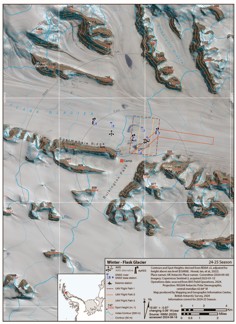
Field Map - Flask Glacier Study Area
- Collections
- Edition
- 1
- Published
- Access
- Restricted
Produced by the Mapping and Geographic Information Centre, British Antarctic Survey, 2025, version 1, https://data.bas.ac.uk/maps/2056.
Map of Flask Glacier focussed on the study area for 25/26 science season, showing planned routes, the location of previous instrument locations from 24/25 season and projected locations of these instruments given estimated flow speed of the glacier. Mapped over a WorldView2 satellite image from January 2025. Contours are shown at 2 m interval. For use in operations planning during the 2025-26 operational season.
Projection: WGS84 UTM Zone 20S, Central Meridian 62.7°W. Vertical Datum: EGM08.
Data sources and references can be found in the lineage.