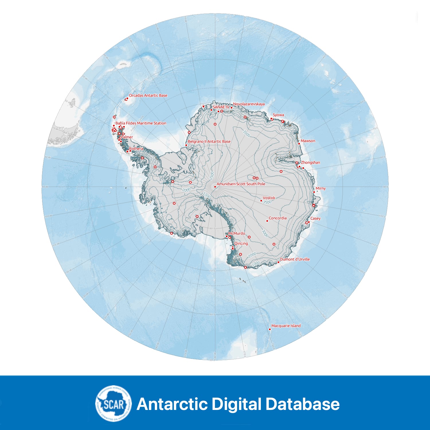
Medium resolution vector contours for Antarctica
- Collections
- Edition
- 7.3
- Published
Please cite this item as: 'Gerrish, L., Fretwell, P., & Cooper, P. (2020). Medium resolution vector contours for Antarctica (7.3) [Data set]. UK Polar Data Centre, Natural Environment Research Council, UK Research & Innovation. https://doi.org/10.5285/0779002b-b95d-432f-b035-b952c36aa5c9'.
A continuous, smoothed contour dataset at 500 m intervals for all land south of 60°S, excluding the Balleny Islands. The vertical datum of the contours is EGM2008. Contours are extracted primarily from the PGC Reference Elevation Model of Antarctica (REMA) v1.1 with certain islands filled from Copernicus WorldDEM. Peter I Øy contours are from the Norwegian Polar Institute. Sources of individual line segments are contained in the attribute table and full compilation information is given in the lineage statement.
Data compiled, managed and distributed by the Mapping and Geographic Information Centre and the UK Polar Data Centre, British Antarctic Survey on behalf of the Scientific Committee on Antarctic Research.
Add this item to a desktop or online GIS that supports ArcGIS Feature Services External link, opens in a new window. .
- Service Endpoint
-
https://services7.arcgis.com/tPxy1hrFDhJfZ0Mf/arcgis/rest/services/add_contours_medium_res_v7_3/FeatureServer
Add this item to a desktop or online GIS that supports ArcGIS Vector Tiles External link, opens in a new window. .
- Service Endpoint
-
https://tiles.arcgis.com/tiles/tPxy1hrFDhJfZ0Mf/arcgis/rest/services/add_contours_medium_res_vt/VectorTileServer
This is a licence summary, see the Formal Licence External link, opens in a new window. for more information.
Bounding Coordinates
- South-West Corner (min x/y)
- South: -90.0, West: -180.0
- North-East Corner (max x/y)
- North: -60.0, East: 180.0
Temporal Range
- Start
- End
Lineage Statement
All processing described here was performed in ArcGIS Pro version 2.6.
A composite Digital Elevation Model (DEM) was created comprising of three datasets from the Reference Elevation Model of Antarctica v1.1: ‘REMA_100m_peninsula_dem_filled’, ‘REMA_100m_dem’ and ‘REMA_200m_dem_filled’. These DEMs were first converted from ellipsoidal height to height above EGM2008 geoid and then mosaicked together in respective order at 100 m spatial resolution. This 100 m DEM was smoothed by performing ‘Focal Statistics’ using a 40x40 cell size.
500 m contours were extracted and all contours with a height <1m were deleted, as well as erroneous offshore contours. In certain locations, primarily some islands on the Antarctic Peninsula, REMA data was insufficient to produce contours. In these places, contours were produced from the ‘Copernicus WorldDEM 90m’ DEM and smoothed by 4 km using a PAEK smoothing algorithm. Contours for Peter I Øy were incorporated from the Norwegian Polar Institute Data at 100 m intervals: 500 m intervals were extracted and smoothed by 800 m, to match the appropriate resolution of the main contours.
All contours were merged together and lines <5 km in length were deleted. Further lines <20 km were deleted in ‘non-mountainous’ regions, so as to avoid deleting small mountain peak contours but to still simplify the main dataset. These regions were interpreted manually using the hillshade of the DEM used to produce the contours.
Original DEM sources and citations:
REMA: Howat, I. M., Porter, C., Smith, B. E., Noh, M.-J., and Morin, P.: The Reference Elevation Model of Antarctica, The Cryosphere, 13, 665-674, https://doi.org/10.5194/tc-13-665-2019, 2019.
Copernicus WorldDEM: produced using Copernicus WorldDEM™-90 © DLR e.V. 2010-2014 and © Airbus Defence and Space GmbH 2014-2018 provided under COPERNICUS by the European Union and ESA; all rights reserved”.
Norwegian Polar Institute (2014). Map data / kartdata Peter I Øy 1:50 000 (P50 Kartdata). Norwegian Polar Institute. https://doi.org/10.21334/npolar.2014.29105abc
Replaces

Continuous, smoothed 500m interval contours for land south of 60°S, generated from REMA v1.1 and other sources.
Part of these collections
Seamless topographic datasets of Antarctica south of 60°S. Compiled from the best available geographic information on behalf of the Scientific Committee on Antarctic Research (SCAR).
Item Information
- Item ID
- 0779002b-b95d-432f-b035-b952c36aa5c9
- Item Type
- DATASET
- Item created
- Item published
- Item updated
- Item released
- Item Status
- Item is complete and recommended for general use
- Item Update Frequency
- Item may be updated if needed
Metadata Information
- Last updated
- Metadata Standard
- ISO 19115-2 Geographic Information - Metadata - Part 2: Extensions for Imagery and Gridded Data
- Metadata Standard Version
- ISO 19115-2:2009(E)
- Metadata Profiles
-
- British Antarctic Survey (BAS) Mapping and Geographic Information Centre (MAGIC) Discovery Metadata Profile (v2) External link, opens in a new window.
- British Antarctic Survey (BAS) Mapping and Geographic Information Centre (MAGIC) Administration Metadata Profile (v1) External link, opens in a new window.
- Metadata Licence
- Creative Commons Attribution-NoDerivatives 4.0 International External link, opens in a new window.
- Metadata Links
- Item page build time
Alternative contact methods
By post
British Antarctic SurveyHigh Cross
Madingley Road
Cambridge
Cambridgeshire
CB3 0ET
United Kingdom
By phone
By email
Privacy Notice
If you contact us, your personal information will be retained for up to three years and then deleted. It will only be used to contact you regarding your enquiry. If this item relates to an external organisation, we may share an anonymised version of your enquiry with them to help answer your query.
We use Cloudflare Turnstile, a third-party service, to protect against spam enquires.
See our privacy policy for more information.